Record-breaking warm temperatures in Ottawa
Ottawa broke a 78-year-old temperature record Wednesday, as a late summer heat wave continues in the national capital region.
Environment Canada's forecast called for a high of 33 C today, with the humidex making it feel like 40 degrees. The record for hottest Sept. 6 in Ottawa history is 31.7 C, set back in 1945.
The temperature hit 31.9 C at 5 p.m., with the humidex making it feel like 41 degrees.
A heat warning remains in effect for Ottawa.
"A hot and humid airmass atypical of early September is expected through Thursday," Environment Canada said in a statement.
"Daytime highs are expected to be 30 to 34 C. Overnight lows are expected to be 19 to 22 C bringing little relief from the heat. The passage of a cold front will bring an end to the heat Friday."
The high hit 32.5 C on Tuesday, just shy of the record for warmest Sept. 5 in Ottawa of 33.1 C.
The forecast calls for a mix of sun and cloud today. High 33 C, with the humidex making it feel like 40 degrees.
Partly cloudy with a 40 per cent chance of showers tonight. There is a risk of a thunderstorm this evening and after midnight. Low 20 C.
Mainly cloudy on Thursday with a chance of showers. High 29 C, with the humidex making it feel like 37 degrees.
Friday will be mainly cloudy with a 60 per cent chance of showers. High 23 C.
The outlook for Saturday calls for a mix of sun and cloud with a 40 per cent chance of showers. High 22 C.
Sunday will see a mix of sun and cloud, with a high of 23 C.
The normal temperatures for this time of year are a high of 21 C and a low of 11 C.


CTVNews.ca Top Stories

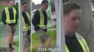
Serial sexual offender linked to unsolved 1970s homicides of four Calgary girls, women
An investigation into unsolved historical homicides from the 1970s has linked the deaths of two girls and two young women in and around Calgary to a now-deceased serial offender.
Woman with liver failure rejected for a transplant after medical review highlights alcohol use
For nearly three months, Amanda Huska has been in an Ontario hospital, part of it on life support, because of severe liver failure. Her history of alcohol use is getting in the way of her only potential treatment: a liver transplant.
Dabney Coleman, actor who specialized in curmudgeons, dies at 92
Dabney Coleman, the mustachioed character actor who specialized in smarmy villains like the chauvinist boss in '9 to 5' and the nasty TV director in 'Tootsie,' has died. He was 92.
Information commissioner faces $700K funding shortfall, says system is 'overwhelmed'
Canada's information commissioner says her office is facing a $700,000 funding shortfall that could impact its ability to investigate complaints about government transparency and accountability.
BREAKING
BREAKING Craig Berube named as next head coach of Toronto Maple Leafs
The Toronto Maple Leafs have named Craig Berube as their new head coach.
B.C. man 'attacked suddenly' by adult grizzly near Alberta boundary: RCMP
A B.C. man is recovering from multiple injuries after he was "attacked suddenly" by an adult grizzly bear near Elkford Thursday afternoon.
Australia's richest woman seeks removal of her portrait from exhibition
Art is subjective. And while many artists long to share their work with the world, there's no guarantee that the audience will understand it, or even like it.
Backlash over NFL player Harrison Butker's commencement speech has reached a new level
The NFL is distancing itself from controversial comments by Kansas City Chiefs kicker Harrison Butker during a recent commencement address.
Person charged in random assault on actor Steve Buscemi in New York
A person wanted in connection with the random assault on actor Steve Buscemi on a New York City street earlier this month was taken into custody Friday, police said.
Shopping Trends
The Shopping Trends team is independent of the journalists at CTV News. We may earn a commission when you use our links to shop. Read about us.


Atlantic
-

Campers issued ticket after Halifax firefighters forced to extinguish fire in Stillwater Lake, N.S.
Two campers have been issued a ticket after Halifax firefighters had to extinguish a fire in Stillwater Lake, N.S., Friday.
-
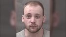
Guilty on all charges: Colin Tweedie convicted in hit-and-run death of 10-year-old Cape Breton girl
A judge has found Colin Tweedie guilty on three counts in connection to the death of 10-year-old Talia Forrest on a Cape Breton road on July 11, 2019.
-
Parents of teen seen in video of altercation in Fredericton calling for better education, kindness
The parents of one of the teens seen in a video that’s been widely circulated in Fredericton and beyond are calling for change.
Toronto
-

Feds refuse Toronto's request to decriminalize simple drug possession
The federal government has denied Toronto's request to decriminalize simple possession of small amounts of drugs for personal use.
-
Longtime Toronto city councillor Jaye Robinson has died, her office says
Jaye Robinson – a four-term city councillor who represented Ward 15 – Don Valley West for almost 14 years and also served for a time as chair of the TTC – has died.
-
BREAKING
BREAKING Craig Berube named as next head coach of Toronto Maple Leafs
The Toronto Maple Leafs have named Craig Berube as their new head coach.
Montreal
-

2 men plead guilty in Leonardo Rizzuto attempted murder
Two men pleaded guilty to the 2023 attempted murder of Leonardo Rizzuto, the youngest son of the late reputed Mafia boss Vito Rizzuto.
-
Quebec cyclist group seeking government funding for new safety campaign
A group promoting the benefits of cycling wants to raise awareness among bike enthusiasts and is taking its message straight to the bike paths, but says it needs funding from the Ministry of Transport.
-
McGill University to seek second injunction to remove pro-Palestinian encampment
McGill University is not done seeking legal action to remove the pro-Palestinian encampment on its campus, as it said on Friday that it would seek a second injunction to remove protesters from its property.
Northern Ontario
-

Woman with liver failure rejected for a transplant after medical review highlights alcohol use
For nearly three months, Amanda Huska has been in an Ontario hospital, part of it on life support, because of severe liver failure. Her history of alcohol use is getting in the way of her only potential treatment: a liver transplant.
-
Northern Ont. man jailed 10 days for fishing violations
A Sault Ste. Marie man has been jailed for 10 days for failing to comply with a court order banning him from fishing.
-
Stumbling impaired driver in the Sault was on wrong side of the road, crashed into a house
A 29-year-old suspect in Sault Ste. Marie has been charged after police received reports this week of an extremely intoxicated person getting into a vehicle.
Windsor
-

Windsor Regional Hospital CEO David Musyj heading to LHSC
Windsor Regional Hospital president and CEO David Musyj is leaving his position in Windsor and heading to London.
-
IN PICTURES: K9 officer training in progress
New trainees are hard at with the Windsor Police Service Canine Unit this week.
-
'They're beautiful vessels and we're lucky to have them here': Cruise ship season sailing into Windsor-Essex
The 2024 Great Lakes cruising season in Windsor-Essex is shaping up to be busy, with 30 cruise ships and luxury liners scheduled to dock in Windsor and Leamington.
London
-

London mother sentenced in stabbing death of former Helix guitarist
A London, Ont. mother of five was sentenced to seven years in prison Friday for her part in the stabbing death of Daniel Fawcett, the ex-guitarist for the rock band Helix.
-
OPP issue warning over 'senior assassin' game involving water guns
Police in Oxford County are warning the public after several recent weapons calls related to a trendy new game popular with teens.
-
BREAKING
BREAKING Craig Berube named as next head coach of Toronto Maple Leafs
The Toronto Maple Leafs have named Craig Berube as their new head coach.
Kitchener
-

Impaired driver sentenced to 7 years after double-fatal Cambridge crash
A driver, charged with impaired driving, has been sentenced to seven years behind bars after two people were killed in a Cambridge crash.
-
New tech tool used in search for missing Kitchener man
Waterloo regional police used a new tech tool as part of their search for a missing elderly man this week.
-
Cambridge woman found not criminally responsible in fatal stabbing of her daughter
A Cambridge woman charged with second-degree murder in connection to the fatal 2020 stabbing of her daughter has been found not criminally responsible.
Barrie
-
'You ruined my childhood,' Survivors face Innisfil child predator at sentencing hearing
An Innisfil man guilty of sex crimes involving young girls was back in court on Friday as his sentencing hearing got underway with emotional victim impact statements.
-
Township's photo radar cameras generate over $333,000 in fines in 3 months
Speed cameras in Essa Township have collected a hefty fee since they were first installed three months ago.
-
City of Barrie highlights bylaws, asking residents to 'be a good neighbour'
The City of Barrie is reminding residents about the importance of adhering to municipal bylaws and the potential repercussions of non-compliance, asking everyone to "be a good neighbour."
Winnipeg
-
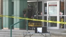 UPDATED
UPDATED Bomb unit removes 'volatile substance' from Winnipeg hospital research centre
The Winnipeg police bomb unit removed a 'volatile substance' from a Winnipeg hospital research centre Friday afternoon, prompting an evacuation.
-
Cleanup, damage assessment underway after Winnipeg thunderstorm and hail
Winnipeggers were left surveying the damage and cleaning up after a thunderstorm rolled through the city Thursday afternoon.
-
Southwestern Manitoba under severe thunderstorm watch
Less than a day after a thunderstorm rolled through Manitoba, bringing hail, heavy winds, and a tornado warning, Environment and Climate Change Canada (ECCC) say a severe thunderstorm is possible on Friday.
Calgary
-
Serial sexual offender linked to unsolved 1970s homicides of four Calgary girls, women
An investigation into unsolved historical homicides from the 1970s has linked the deaths of two girls and two young women in and around Calgary to a now-deceased serial offender.
-
Alberta Medical Association sounds alarm over lack of available oncologists
The Alberta Medical Association is expressing deep concerns to the provincial government over a lack of oncologists needed to provide cancer care to keep up with population growth.
-
B.C.'s short-term rental rules not needed in Alberta, according to those trying to fix housing crisis
British Columbia's provincial government implemented new rules to limit short-term housing at the start of May. But those working to solve the housing crisis Albertans are facing aren't convinced such rules are needed here.
Edmonton
-
Police searching for black Ford Fusion after road rage incident in Edmonton
Police are looking for three people after a road rage incident in south Edmonton on Friday morning.
-
Cat that escaped burning Jasper Avenue balcony up for adoption
A cat that jumped ship from a burning balcony on Jasper Avenue three weeks ago and survived is looking for a new home.
-
Oilers focus on Saturday's game, try to ignore prospect of elimination from playoffs
They're on the verge of being eliminated, but there's only one thing the Edmonton Oilers can do, says their coach: Remain focused.
Regina
-

Sask. Teachers' Federation recommending tentative deal with province to members
The Saskatchewan Teachers' Federation (STF) and province announced that a tentative agreement had been reached on Friday afternoon, with the STF recommending and endorsing the potential deal to teachers.
-
'Unequivocally false': Sask. premier says of legislative Speakers' claims of harassment, intimidation
Saskatchewan Premier Scott Moe says claims of intimidation and harassment by legislative Speaker Randy Weekes are 'unequivocally false.'
-
Sask. doctor says physicians aren’t being paid correctly under province’s new billing system
A Saskatoon family doctor says the province’s new billing system is a disaster.
Saskatoon
-

Sask. doctor says physicians aren’t being paid correctly under province’s new billing system
A Saskatoon family doctor says the province’s new billing system is a disaster.
-
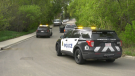
'The car was half inside my children's room': Car crashes into Saskatoon apartment building
Firefighters responded to a scene on the 300 Block of Herold Road Friday morning after a car collided with an apartment building.
-
Sask. Teachers' Federation recommending tentative deal with province to members
The Saskatchewan Teachers' Federation (STF) and province announced that a tentative agreement had been reached on Friday afternoon, with the STF recommending and endorsing the potential deal to teachers.
Vancouver
-

B.C. court rules on condo purchase dispute that ended long-term friendship
A Vancouver condo owner was right to keep more than $300,000 her former friend paid her toward the purchase of the property before backing out of an assignment sale agreement, the B.C. Supreme Court has ruled.
-
'Unconscionable': B.C. mayor warns against sharing videos of properties destroyed by fire
The mayor of a northeast British Columbia community threatened by wildfires is warning people who stayed behind in the evacuation zone to stay on their properties and not share images of fire destruction on social media.
-
Stolen excavator recovered using GPS in Maple Ridge, RCMP say
Mounties in Maple Ridge recovered more than $200,000 worth of stolen property, including a Bobcat compact excavator, after following a theft victim's GPS locator last week.
Vancouver Island
-

Police remain tight-lipped one year after crash killed municipal worker near Victoria
One year after an allegedly reckless driver careened into a municipal park east of Victoria, killing a 52-year-old husband and father of two young children, there are few answers about what led to the crash and no criminal charges have been forwarded to prosecutors.
-
'Unconscionable': B.C. mayor warns against sharing videos of properties destroyed by fire
The mayor of a northeast British Columbia community threatened by wildfires is warning people who stayed behind in the evacuation zone to stay on their properties and not share images of fire destruction on social media.
-
B.C. man 'attacked suddenly' by adult grizzly near Alberta boundary: RCMP
A B.C. man is recovering from multiple injuries after he was "attacked suddenly" by an adult grizzly bear near Elkford Thursday afternoon.
Kelowna
-
'Altercation' in Penticton leaves 1 dead: RCMP
One person is dead after a fight in Penticton early Sunday morning, according to authorities.
-
Suspect fled in 2-door Fiat after convenience store robbery, Merritt RCMP say
A suspect is at large after robbing a convenience store at gunpoint in Merritt, B.C., Friday, according to local police.
-
Kamloops RCMP issue public warning about 2 men allegedly at centre of 'organized crime conflict'
After four targeted shootings in four days, Mounties in Kamloops are taking the unusual step of warning the public about two men they believe are likely to be targeted in future violent incidents.


