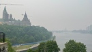
Here's when Ottawa could see up to 10 cm of snow during March Break
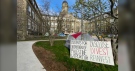
 A snowman enjoys a sunny morning in Confederation Park in downtown Ottawa. (Josh Pringle/CTV News Ottawa)
As we "spring forward" into daylight saving time, Mother Nature is set to remind us it's still winter.
Daylight saving time began at 2 a.m. Sunday, with clocks moving ahead one hour. Daylight saving time will end on Nov. 5, at 2 a.m.
It will be a snowy start to March Break in the capital with Environment Canada calling for up to 10 centimetres of snow by Tuesday.
The forecast calls for 2 to 4 centimetres of snow on Monday, with an additional 2 to 4 centimetres of snow Monday night. Environment Canada is calling for periods of snow to continue on Tuesday with an additional 2 to 4 centimetres falling in the capital.
Ottawa has already received 308.5 centimetres of snow this winter, the second-highest snowfall total over the past 20 winters.
Forecast
There will be periods of snow throughout the day on Monday, possibly becoming mixed with rain late in the afternoon. Today's forecast high is 2 C.
The snow will continue this evening and temperatures will fall to 0 C overnight.
Expect periods of snow on Tuesday and a high of 2 C. It will be cloudy Tuesday evening with a 60 per cent chance of flurries. Temperatures will fall to -4 C overnight.
On Wednesday - a mix of sun and cloud and a high of 5 C.
Ottawa Top Stories
-
-
-
-
-
-
-
 NEW THIS MORNING
NEW THIS MORNING Human chess game turns Parliament Hill black and white for Alzheimer's research
-


CTVNews.ca Top Stories
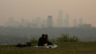
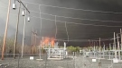
Air quality advisories issued in 5 provinces, 1 territory
Air quality advisories are in effect across Western Canada as smoky conditions plague some areas, according to the latest forecasts. Here's where.
'Oh my God, you're my brother': Man in his 70s discovers 6 unknown siblings
After receiving a DNA kit one Christmas from his son-in-law, Hugh McCormick soon discovered that he had six unknown siblings, with whom he shared the same birth parents.
No refund for travellers who cancelled flight already scrapped by airline: regulator
Four years on, the controversy over whether airlines owed refunds to passengers after cancelling hundreds of thousands of flights during the pandemic continues to simmer, aggravated by a sluggish, opaque complaints process.
Just how bad are ultraprocessed foods? Here are 5 things to know
Many foods fall under the category of ultraprocessed foods, depending on their exact ingredients. This type of food has been studied a lot lately, and the results aren’t great.
'My family doctor just fired me': Ontario patients frustrated with de-rostering
Dozens of Ontarians are expressing frustration in the province’s health-care system after their family doctors either dropped them as patients or threatened to after they sought urgent care elsewhere.
Rates of cancer declining in Canada, but more work needed to save lives: projections
A new study projecting declining rates of cancer cases and deaths in Canada demonstrates the success of prevention and early detection programs, but also highlights areas where more work is needed to save and prolong lives, researchers say.
DEVELOPING
DEVELOPING Trump trial arrives at a pivotal moment: Star witness Michael Cohen is poised to take the stand
The star prosecution witness in Donald Trump's hush money trial is set to take the stand Monday with testimony that could help shape the outcome of the first criminal case against an American president.
India's mammoth election is more than halfway done as millions begin voting in fourth round
Millions of Indians across 96 constituencies began casting their ballots on Monday as the country's gigantic, six-week-long election edges past its halfway mark. Prime Minister Narendra Modi is seeking a third straight term with an eye on winning a supermajority in Parliament.
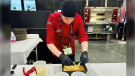
Ottawa pizzeria places among top 20 deep-dish pizzas in the world at international competition
An Ottawa pizzeria is being recognized as one of the top 20 deep-dish pizzas in the world.
Shopping Trends
The Shopping Trends team is independent of the journalists at CTV News. We may earn a commission when you use our links to shop. Read about us.


Atlantic
-
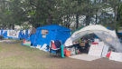
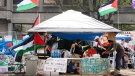
Pro-Palestinian encampment set up at Halifax’s Dalhousie University
An encampment is now set up outside a Maritime university in solidarity with Palestinian people in Gaza amid the ongoing Israel-Hamas war.
-
No refund for travellers who cancelled flight already scrapped by airline: regulator
Four years on, the controversy over whether airlines owed refunds to passengers after cancelling hundreds of thousands of flights during the pandemic continues to simmer, aggravated by a sluggish, opaque complaints process.
-
Halifax home significantly damaged by fire, one person sent to hospital
An early morning fire in Halifax has damaged a home and sent one person to hospital.
Toronto
-

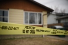
Police identify woman shot and killed in Oakwood Village; suspect arrested
A 27-year-old man has been charged with murder in connection with the fatal shooting of a woman at a residence in the city’s Oakwood Village neighbourhood over the weekend, Toronto police say.
-
Ontario's need for nurses, PSWs to top 33K and 50K by 2032: document
Ontario will need 33,200 more nurses and 50,853 more personal support workers by 2032, the government projects — figures it tried to keep secret but were obtained by The Canadian Press.
-
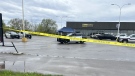
2 people critically injured in North York shooting: paramedics
Two people suffered life-threatening injuries after a shooting in North York early Monday morning, Toronto police say.
Montreal
-
McGill to ask for injunction to dismantle pro-Palestinian encampment
Lawyers for McGill University are slated to be in court to seek an injunction to dismantle the pro-Palestinian encampment that has been on its grounds since last month.
-
Amazon's Laval warehouse workers now unionized
The 200 workers at Amazon's Laval warehouse have succeeded where many other employees of the American multinational have failed: they are now unionized.
-
Man sent for 'psychological care' after gunfire in Longueuil
A string of shootings in Greenfield Park on Montreal's South Shore had Longueuil police investigating overnight.
Northern Ontario
-
37-year-old man dies following Sault police shooting
Ontario’s police watchdog is investigating after a Sault Ste. Marie Police Service officer shot a 37-year-old man in the city’s west end on Saturday night.
-
'Oh my God, you're my brother': Man in his 70s discovers 6 unknown siblings
After receiving a DNA kit one Christmas from his son-in-law, Hugh McCormick soon discovered that he had six unknown siblings, with whom he shared the same birth parents.
-
'My family doctor just fired me': Ontario patients frustrated with de-rostering
Dozens of Ontarians are expressing frustration in the province’s health-care system after their family doctors either dropped them as patients or threatened to after they sought urgent care elsewhere.
Windsor
-

Chatham police seek break and enter suspect
Police in Chatham-Kent are hoping the public can identify a person they’re looking for. According to police, the person is suspected in relation to multiple break and enter and attempt break-and-enter investigations in Chatham.
-
Showers and a spike in the temperature on Monday
The temperature will be well above normal in Windsor-Essex on Monday as rain showers continue throughout the day.
-
Teachers among those charged in underage prostitution investigation
Days after four people were charged in an underage prostitution investigation, it's been learned that two of the accused are reportedly employed by the University of Windsor and a high school in Essex.
London
-

Showers and heat in London area on Monday
With rain showers expected most of the day, the temperature will hit a high around 25 C. The normal for this time of year being around 20 C.
-
Fire crews tackle east end blaze early Sunday morning
No injuries were reported after a garage fire spread into a vehicle early Sunday morning in the city’s east end.
-
Jewelery owner assaulted during robbery, suspect in custody
A 46-year-old individual is in custody and is facing multiple charges after allegedly robbing a Kincardine jewelery store early Saturday morning and assaulting the business owner.
Kitchener
-
Gunshots ring out in Kitchener neighbourhood
Waterloo regional police say no one was hurt during a daylight shooting in Kitchener.
-
'He's in our hearts': Family and friends still seek answers one year after Nathan Wise's disappearance
It’s been a year since Nathan Wise went missing and his family is no closer to finding out what happened to him.
-
Ontario's need for nurses, PSWs to top 33K and 50K by 2032: document
Ontario will need 33,200 more nurses and 50,853 more personal support workers by 2032, the government projects — figures it tried to keep secret but were obtained by The Canadian Press.
Barrie
-

'Phenomenal mom' killed in Innisfil crash
Young mother was killed in a two-vehicle crash in Innisfil Saturday morning.
-
Collingwood waste site goes up in smoke
A garbage fire was attended to by Collingwood firefighters Monday.
-
Motorcyclist airlifted to hospital after vehicle collision
A motorcyclist was airlifted to a local hospital after being struck by a vehicle in Grey Highlands.
Winnipeg
-
Manitoba battling two wildfires around Flin Flon and The Pas, evacuation orders in effect
The province says several government agencies are currently responding to two wildfires around Flin Flon and The Pas.
-
Trial of Winnipeg serial killer expected to hear more testimony from police
The Winnipeg trial of admitted serial killer Jeremy Skibicki is expected to hear testimony today from a police officer who examined video surveillance.
-
Air quality advisories issued in 5 provinces, 1 territory
Air quality advisories are in effect across Western Canada as smoky conditions plague some areas, according to the latest forecasts. Here's where.
Calgary
-

Calgary council to make final rezoning amendments and cast vote
City council will make final changes to its blanket rezoning proposal and likely cast their ballots on the issue Monday.
-
Sunday morning collision between vehicle and cyclist sends 1 to hospital
A vehicle collided with a cyclist Sunday morning in southeast Calgary.
-
Calgary Stampeders' training camp opens with an abundance of quarterbacks
Quarterback meetings were crowded to start Calgary Stampeders' training camp.
Edmonton
-
 WEATHER
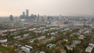
WEATHER Josh Classen's forecast: Average temperatures and a reprieve from the smoke
The thick wildfire smoke that blew in from the northwest over the weekend has moved out of the Edmonton area and modelling indicates "cleaner" air for Monday/Tuesday in the Edmonton area and all of central and southern Alberta.
-
Canucks hold off Oilers for 4-3 win in Game 3
Brock Boeser had two goals and an assist, and the Vancouver Canucks hung on for a 4-3 win over the Edmonton Oilers in Game 3 of their second-round Stanley Cup playoff series.
-
U of A defends decision to involve police in teardown of campus protest encampment
Multiple people at the protest camp torn down at the University of Alberta campus Saturday say police's actions against protesters were "violent" and "disproportionate."
Regina
-
Death investigation underway after injured man dies in hospital
Regina police have launched an investigation into the death of a man officers found gravely injured in the northwest of the city on Sunday.
-
'Genuine optimism': Riders open 2024 training camp with Harris at the helm
Sunday marked day one of training camp for the Saskatchewan Roughriders in Saskatoon. The team was ecstatic to be back on the field for another year with quarterback Trevor Harris being no exception.
-
Sask. social services mobile outreach team doubles in size, expands access to community locations
Saskatchewan's Ministry of Social Services says its mobile outreach team is doubling in size. A total of 20 social workers will now provide services in the community rather than from a government office.
Saskatoon
-
Saskatoon police say violent crime is up 10 per cent since last year
Violent crime in Saskatoon was up by nearly 10 per cent in the first quarter of 2024, according to new data from the Saskatoon Police Service.
-
'It would change my life': Saskatchewan singer vying for $1 million on Canada's Got Talent final
Prince Albert singer Rebecca Strong is on the cusp of achieving a dream on Canada’s Got Talent as she stands among the final eight contestants.
-
No one injured in residential blaze, Saskatoon fire department says
The Saskatoon Fire Department says no one was injured in a fire in the Queen Elizabeth neighbourhood on Saturday evening.
Vancouver
-

Canucks beat Oilers 4-3 to take back series lead
The Vancouver Canucks beat the Edmonton Oilers 4-3 Sunday night and now lead the second round series 2-1.
-
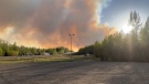
'It happened so fast': Evacuees describe fleeing Fort Nelson wildfire
Thousands have been forced to flee a wildfire burning near Fort Nelson. Meanwhile, some experienced volunteers are staying behind to fight the fire.
-
Wind could push rapidly growing wildfire into Fort Nelson, B.C.: BCWS
A fast-growing wildfire near Fort Nelson, B.C., that has forced thousands to flee their homes could spread into the town itself, the B.C. Wildfire Service warned.
Vancouver Island
-
Wind could push rapidly growing wildfire into Fort Nelson, B.C.: BCWS
A fast-growing wildfire near Fort Nelson, B.C., that has forced thousands to flee their homes could spread into the town itself, the B.C. Wildfire Service warned.
-
Canucks beat Oilers 4-3 to take back series lead
The Vancouver Canucks beat the Edmonton Oilers 4-3 Sunday night and now lead the second round series 2-1.
-
'It happened so fast': Evacuees describe fleeing Fort Nelson wildfire
Thousands have been forced to flee a wildfire burning near Fort Nelson. Meanwhile, some experienced volunteers are staying behind to fight the fire.
Kelowna
-
'Altercation' in Penticton leaves 1 dead: RCMP
One person is dead after a fight in Penticton early Sunday morning, according to authorities.
-
Suspect fled in 2-door Fiat after convenience store robbery, Merritt RCMP say
A suspect is at large after robbing a convenience store at gunpoint in Merritt, B.C., Friday, according to local police.
-
Kamloops RCMP issue public warning about 2 men allegedly at centre of 'organized crime conflict'
After four targeted shootings in four days, Mounties in Kamloops are taking the unusual step of warning the public about two men they believe are likely to be targeted in future violent incidents.


