Two tornadoes with wind speeds of 155 km/h touched down in Ottawa on Thursday
Two tornadoes touched down in the south Ottawa suburb of Barrhaven on Thursday, with the second tornado crossing the path of the first one, according to researchers.
More than 100 homes were damaged when the two EF1 tornadoes, with maximum wind speeds of 155 km/h, left two paths of damage approximately 1 km and 5 km long during severe weather on Thursday. One minor injury was reported due to the storm.
Investigators with Western University's Northern Tornadoes Project wrapped up the damage survey and analysis in Barrhaven on Saturday afternoon.
"It was a complicated one: two tornadoes, with the 2nd crossing the path of the 1st," Northern Tornadoes Project said on Twitter.
According to a media release from the Northern Tornadoes Project, the main path of damage extends approximately 5 kilometres, with a maximum width of 200 metres.
"A second shorter damage path that crosses the main path, approximately 1 km in length with a maximum width of 150 m, was caused by a slightly earlier tornado," Northern Tornadoes Project said.
A tornado touched down at 12:44 p.m., while the second tornado touched down at 12:45 p.m.
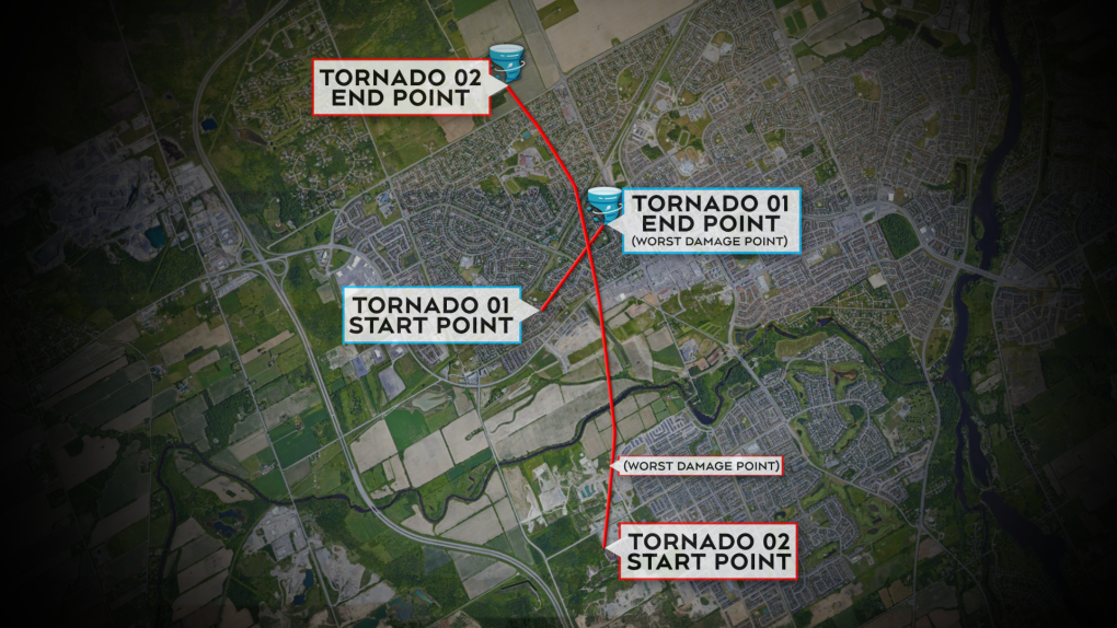
 Western University's Northern Tornadoes Project says two tornadoes touched down in Ottawa last Thursday. Here is a look at the path of the two tornadoes.
The first tornado touched down in the area of Halley Street, near Strandherd Drive, and travelled to the area of Exeter Drive and Chester Crescent, according to the Northern Tornadoes Project. The most extensive damage was in the area of Halley Street and Pepperrall Crescent.
The second tornado touched down in the area of Cambrian Road and Elevation Road and travelled to south of Fallowfield Road, near Greenbank Road. The worst of the damage was in the area of Proxima Terrace and Regulus Ridge.
"Between the oddness of the damage, as well as some of the video that we had seen from the event, that's what made us suspect there were at least two tornadoes," Connell Miller, engineering researcher with Western University's Northern Tornadoes Project, told CTV News Ottawa.
"When we sort of plotted it all on a map, we were able to see two clear, distinct tornado paths from that damage."
The city of Ottawa said 125 homes had significant damage in three areas: Umbra Place/Watercolours Way area, Perseus Way/Proxima Terrace area and the Jockvale Road/Exeter Drive area.
Researchers say based on the damage scale, both tornadoes had maximum wind speeds of 155 km/h, which falls in the EF1 category.
"EF1 is still on the lower end of that scale and is one of the more common ratings that we give a tornado," Miller said.
"The Ottawa region and southwestern Ontario in general does have a tendency to have a high frequency of tornado occurrence."
This was the first tornado to touch down in Ottawa since 2019, when a tornado touched down in Orleans.
Western University Northern Tornadoes Project says it will continue to do some analysis on the storm, so the length and width of the tornadoes is preliminary.
"Note that length and width values for each tornado are preliminary as additional photo and video evidence is still being received and further analysis is required," researchers said.
 Ottawa police say there are reports of a tornado in the Barrhaven area on Friday. (Grant Pope/submitted)
Environment Canada and the Western University Northern Tornadoes Project initially confirmed at least one tornado touched down in Barrhaven during Thursday's storm.
Miller told Newstalk 580 CFRA's CFRA Live with Andrew Pinsent on Saturday morning that tornadoes often follow similar patterns, dealing a thin line of damage that is much longer than it is wide; however, all of the videos and images shared of the event Thursday raised questions for researchers.
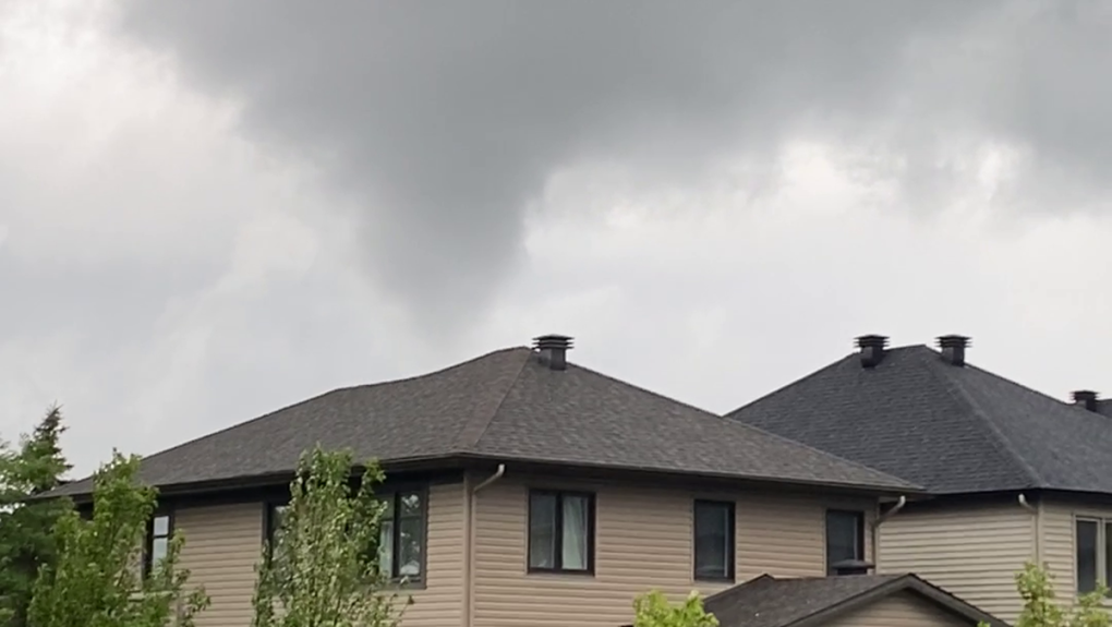
"There was lots of videos and photos submitted on social media and when we started looking at where it was filmed and the angles, it started to not make sense a little bit," Miller said. "So, we went looking in those areas where the videos were showing there may be a second tornado and we started finding damage, so we're actively trying to figure out how many tornadoes impacted the area."
Miller said researchers found a lot of structural damage, such as shingles and cladding gone, roof decking ripped but no roofs were completely ripped off.
"You see things indicative of a tornado, you see 2x4s thrown and embedded, that's a really classic sign of a tornado. You tend to see specific patterns of debris, where it started and where it ended up, all of it indicating at least one tornado in the area," he explained.
The city of Ottawa says curbside removal of tree and yard debris will begin next week.
Here is what we know about the two tornadoes that touched down in Barrhaven
Tornado 1
Western University's Northern Tornadoes Project says the first tornado touched down at 12:44 p.m. on Thursday.
It was an EF1 tornado, with maximum winds of 155 km/h.
Start of tornado track: The tornado touched down in the area of Halley Street and Pepperrall Crescent. The tornado motion was from the southwest.
Worst of the damage: Halley Street area
End of tornado track: Moloughney Park/Exeter Drive area.
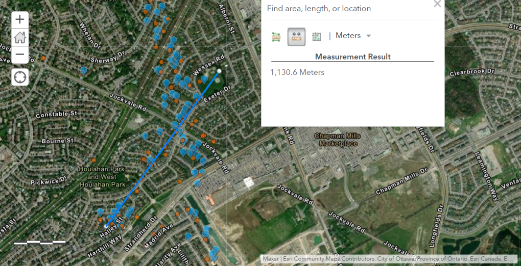
The tornado travelled from southwest to northeast. Researchers say the preliminary track length of the tornado is 1.13 km and a max. path width of 150 metres.
 Western University's Northern Tornadoes Project released a map showing the preliminary track of one of the two tornadoes that touched down in Barrhaven. The dots indicate where researchers look ground photos and drone imagery. (Northern Tornadoes Project/release)
Tornado 2
The second tornado touched down in Barrhaven's south end at 12:45 p.m.
It was an EF1 tornado, with maximum winds of 155 km/h.
Start of tornado track: The tornado touched down in the area of Elevation Road and Cambrian Road. The tornado motion was from the south.
Worst of the damage: The area of Regulus Ridge and Proxima Terrace. The city of Ottawa said 35 homes in the area of Perseus Way and Proxima Terrance suffered extensive damage.
End of tornado track: Fallowfield Road, near Orr Street.
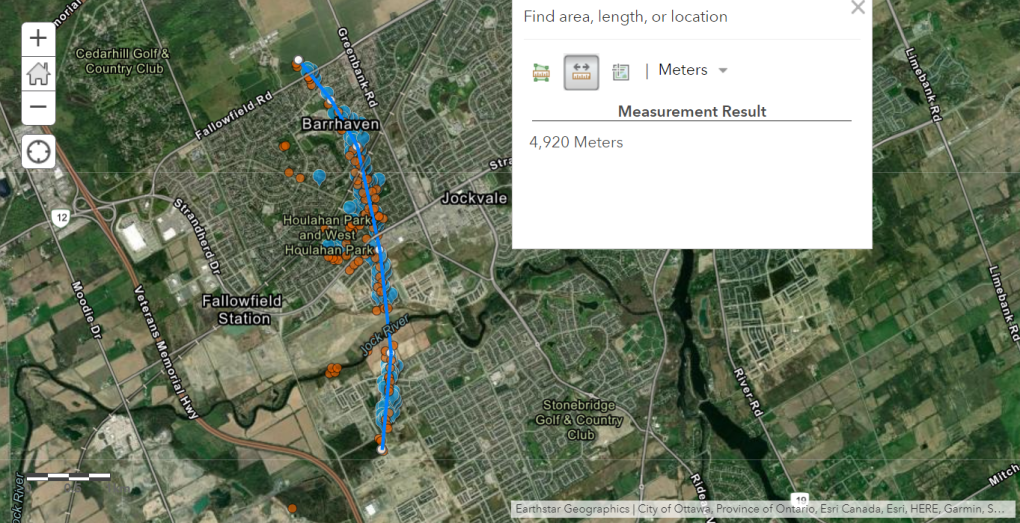
The tornado travelled south to north. Researchers say the preliminary track length for the tornado is 4.92 km and a maximum path wide of 200 metres.
 Western University's Northern Tornadoes Project released a map showing the track and length of a tornado that touched down in Barrhaven on Thursday. The dots indicate where researchers look ground photos and drone imagery. (Northern Tornadoes Project/release)
CTVNews.ca Top Stories

From essential goods to common stocking stuffers, Trudeau offering Canadians temporary tax relief
Canadians will soon receive a temporary tax break on several items, along with a one-time $250 rebate, Prime Minister Justin Trudeau announced Thursday.
She thought her children just had a cough or fever. A mother shares sons' experience with walking pneumonia
A mother shares with CTVNews.ca her family's health scare as medical experts say cases of the disease and other respiratory illnesses have surged, filling up emergency departments nationwide.
Trump chooses Pam Bondi for attorney general pick after Gaetz withdraws
U.S. president-elect Donald Trump on Thursday named Pam Bondi, the former attorney general of Florida, to be U.S. attorney general just hours after his other choice, Matt Gaetz, withdrew his name from consideration.
A one-of-a-kind Royal Canadian Mint coin sells for more than $1.5M
A rare one-of-a-kind pure gold coin from the Royal Canadian Mint has sold for more than $1.5 million. The 99.99 per cent pure gold coin, named 'The Dance Screen (The Scream Too),' weighs a whopping 10 kilograms and surpassed the previous record for a coin offered at an auction in Canada.
Putin says Russia attacked Ukraine with a new missile that he claims the West can't stop
Russian President Vladimir Putin announced Thursday that Moscow has tested a new intermediate-range missile in a strike on Ukraine, and he warned that it could use the weapon against countries that have allowed Kyiv to use their missiles to strike Russia.
Here's a list of items that will be GST/HST-free over the holidays
Canadians won't have to pay GST on a selection of items this holiday season, the prime minister vowed on Thursday.
Video shows octopus 'hanging on for dear life' during bomb cyclone off B.C. coast
Humans weren’t the only ones who struggled through the bomb cyclone that formed off the B.C. coast this week, bringing intense winds and choppy seas.
Taylor Swift's motorcade spotted along Toronto's Gardiner Expressway
Taylor Swift is officially back in Toronto for round two. The popstar princess's motorcade was seen driving along the Gardiner Expressway on Thursday afternoon, making its way to the downtown core ahead of night four of ‘The Eras Tour’ at the Rogers Centre.
Service Canada holding back 85K passports amid Canada Post mail strike
Approximately 85,000 new passports are being held back by Service Canada, which stopped mailing them out a week before the nationwide Canada Post strike.


