Ottawa River flooding could reach May 2017 level in some areas
The Ottawa River Regulation Planning Board is warning residents who live along the Ottawa River that water levels are rising after a weekend of heavy precipitation and could be similar to May 2017 in some areas.
A major weather system brought more than 40 mm of rain to the Ottawa region over the weekend and the board says any remaining snow in the north has melted and run off into the river.
"Minor flood levels are occurring in multiple locations between Mattawa and the Montreal region," the board says. "Major flood levels are expected to be exceeded in flood prone areas over the next few days."
The board says that some areas could see levels similar to or in excess of where they were in May 2017, but water levels should still be 45 cm to 1 m below historic 2019 levels.
Based on the latest weather forecasts and information available as of Monday, the Ottawa River Regulation Planning Board says the following conditions are expected along the main stem of the Ottawa River over the coming week:
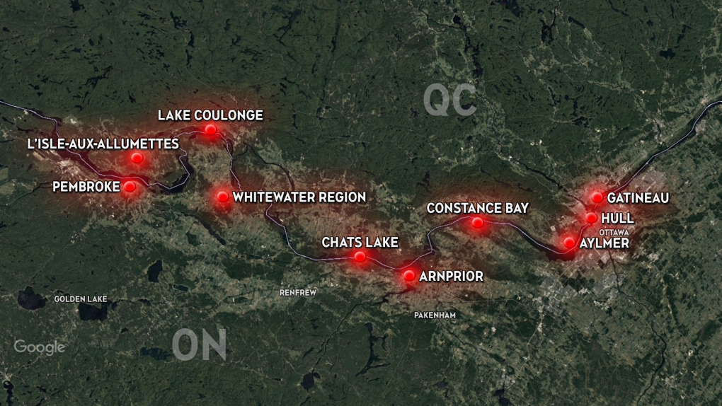 A map of the various areas across the region along the main stem of the Ottawa River that will see water levels exceeding peak levels based on the latest weather forecasts and information available as of Monday, May 1, 2023.
Mattawa: Minor flooding is already occurring. Levels are expected to continue rising until they reach a peak of about 154.55 – 154.60 m on Thursday. This corresponds to a rise in level of 45 to 50 cm compared to the observed level on Monday at 8 a.m.
Pembroke: Minor flooding is already occurring. Levels are expected to continue rising until they reach a peak of about 113.30 m 113.35 m Tuesday or Wednesday. This corresponds to a rise in level of 40 to 45 cm compared to the observed level on Monday at 8 a.m.
Whitewater Region: Levels are expected to exceed peak levels observed last week (April 21-23) by 50 to 55 cm. Flows at that location are expected to slightly exceed those experienced in early May 2017.
L'Isle-aux-Allumettes and Lake Coulonge: Levels are expected to exceed peak levels observed last week (April 21-23) by 50 to 55 cm. Levels at Lake Coulonge are expected to be similar to those observed in early May 2017.
McNab-Braeside, Arnprior and Chats Lake: Levels are expected to exceed peak levels observed last week (April 21-23) by 30 to 35 cm. These levels are lower than those observed in early May 2017.
Constance Bay, Aylmer and Lake Deschenes: Levels are expected to exceed peak levels observed last week (April 21-23) by 25 to 30 cm. These levels are lower than those observed in early May 2017.
Gatineau and Hull to the Montreal region: Levels are expected to exceed peak levels observed last week (April 21-23) by 50 to 60 cm in Gatineau (Hull marina) and Thurso. These levels are approximately 70 cm lower than those observed in early May 2017.
Water levels had stabilized last week prior to the significant rainfall. A flood warning was issued for the lower Ottawa River from Arnprior to Hawkesbury last Friday.
Shopping Trends
The Shopping Trends team is independent of the journalists at CTV News. We may earn a commission when you use our links to shop. Read about us.


CTVNews.ca Top Stories

'Mayday! Mayday! Mayday!': Details emerge in Boeing 737 incident at Montreal airport
New details suggest that there were communication issues between the pilots of a charter flight and the control tower at Montreal's Mirabel airport when a Boeing 737 made an emergency landing on Wednesday.
Trudeau appears unwilling to expand proposed rebate, despite pressure to include seniors
Prime Minister Justin Trudeau does not appear willing to budge on his plan to send a $250 rebate to 'hardworking Canadians,' despite pressure from the opposition to give the money to seniors and people who are not able to work.
Hit man offered $100,000 to kill Montreal crime reporter covering his trial
Political leaders and press freedom groups on Friday were left shell-shocked after Montreal news outlet La Presse revealed that a hit man had offered $100,000 to have one of its crime reporters assassinated.
Cucumbers sold in Ontario, other provinces recalled over possible salmonella contamination
A U.S. company is recalling cucumbers sold in Ontario and other Canadian provinces due to possible salmonella contamination.
Trudeau says no question incoming U.S. president Trump is serious on tariff threat
Prime Minister Justin Trudeau says incoming U.S. president Donald Trump's threats on tariffs should be taken seriously.
John Herdman resigns as head coach of Toronto FC
John Herdman, embroiled in the drone-spying scandal that has dogged Canada Soccer, has resigned as coach of Toronto FC.
Billboard apologizes to Taylor Swift for video snafu
Billboard put together a video of some of Swift’s achievements and used a clip from Kanye West’s music video for the song “Famous.”
In a shock offensive, insurgents breach Syria's largest city for the first time since 2016
Insurgents breached Syria's largest city Friday and clashed with government forces for the first time since 2016, according to a war monitor and fighters, in a surprise attack that sent residents fleeing and added fresh uncertainty to a region reeling from multiple wars.
Canada Bread owner sues Maple Leaf over alleged bread price-fixing
Canada Bread owner Grupo Bimbo is suing Maple Leaf Foods for more than $2 billion, saying it lied about the company's involvement in an alleged bread price-fixing conspiracy.
Atlantic
-

Man charged after Halifax high school placed in hold and secure
A man has been charged after a high school in Halifax was placed in hold and secure Friday morning.
-
Teen arrested in connection with weapons call at Fredericton High School
Fredericton Police Force arrested a 14-year-old boy Thursday in relation to a weapons call at Fredericton High School.
-
P.E.I. steps in to help buy mobile park to allow residents to stay in homes
Residents of Evergreen Village mobile home park in Summerside, P.E.I., who have had an eviction notice looming over their heads may be able to stay in their homes after all.
Toronto
-
 BREAKING
BREAKING Feds announce $758 million in funding for new Line 2 TTC subway trains
The TTC will get funding from the federal government to replace aging trains on Line 2, Deputy Prime Minister Chrystia Freeland has announced.
-
Highway 407 owner says no active buyback discussions with Ontario government
The provincial government is facing increasing pressure to tap into the underused and tolled Highway 407 to alleviate congestion on Highway 401.
-
Officer's inaccurate testimony 'will undoubtedly tarnish the image of the Toronto Police Service:' police tribunal
A Toronto cop who 'derailed' a criminal investigation by 'inaccurately' testifying that he saw drugs in plain view inside a suspect’s car has been demoted for two years after pleading guilty to discreditable conduct, a decision from the police tribunal read.
Montreal
-

Hit man offered $100,000 to kill Montreal crime reporter covering his trial
Political leaders and press freedom groups on Friday were left shell-shocked after Montreal news outlet La Presse revealed that a hit man had offered $100,000 to have one of its crime reporters assassinated.
-
Judge hears from ex-employees of Montreal billionaire Robert Miller in sex abuse lawsuit
A Quebec Superior Court justice will deliberate before deciding whether to authorize a class-action lawsuit against Quebec electronics billionaire Robert Miller, accused of paying minors for sex.
-
Boil-water advisory ends in Montreal North
A precautionary boil-water advisory issued two days ago for the entire Montreal North borough has ended.
Northern Ontario
-

Man fined $10K for abandoning homemade barge in Lake Nipissing
A man from Lavigne, Ont., has been fined $10,000 for abandoning a homemade barge in Lake Nipissing.
-
Another 60 cm of snow possible in the Sault as severe weather continues
Closures and cancellations are piling up in Sault Ste. Marie as a major winter storm continues for another day Friday.
-
Heavy police presence on road in Iroquois Falls
Members of the public are being asked to avoid the area of Nellie Lake Road West in Iroquois Falls.
Windsor
-
 Breaking
Breaking Guilty on all counts: Windsor man convicted of careless driving in Retrofest double fatal collision
The Windsor man charged in connection to the double fatal Retrofest collision has been convicted on all counts.
-
Suspect breaks into home, steals keys and drives off: WPS
Windsor police are asking for help identifying a suspect who allegedly broke into a home, stole keys and drove off with the vehicle.
-
$4,000 in products reported stolen from storage container
Chatham-Kent police are looking for suspects after $4,000 in products were stolen from a storage container in Chatham.
London
-

Crown witness describes chaotic night after bush party shooting
Crown witness Reece Davidson, 21, told the jury that he was at the bush bash off of Pack Road in southwest London with a bunch of his young friends on July 30, 2021.
-
'The only thing you could see were his eyes': Employees pepper sprayed at south London business
Around 4 p.m. on Thursday, police were called to a report of an assault in progress at a business int he 600 block of Wilkins St. near Wellington Road.
-
$20 million investment from WSIB to help Fanshawe College prepare up and coming first responders for mental stress
Fanshawe College and the Workplace Safety Insurance Board (WSIB) have announced a $20 million investment from WSIB to establish the WSIB Centre of Excellence in Immersive Technologies and Simulation for Workplace Safety. It is the largest single research grant in Fanshawe’s history.
Kitchener
-

Region of Waterloo considers reducing, and even cutting, some services to keep tax increase down
The Region of Waterloo is considering reducing or eliminating some services in an effort to lower the potential 2025 tax increase.
-
Erick Buhr to represent himself during sentencing for second-degree murder in death of his grandmother, Viola Erb
Erick Buhr will represent himself as he prepares for sentencing after being convicted of second-degree murder in the death of his grandmother, Viola Erb.
-
Man accused of involvement in massive data breach appears in Kitchener court
The man accused of being behind a massive data breach impacting several large U.S. companies made a brief appearance in Kitchener court Friday.
Barrie
-

Former Ont. teacher charged with sexually assaulting a teen nearly 50 years ago
A senior from Clearview Township faces charges in connection with an investigation into a sexual assault involving a teen nearly 50 years ago.
-
Alleged mastermind behind Ontario woman's presumed death seeks bail
The man facing first-degree murder and kidnapping charges in the disappearance of Ontario woman Elnaz Hajtamiri took another shot at bail on Friday in a Barrie courtroom. Mohamad Lilo, 37, has been behind bars since his arrest more than two years ago.
-
50 cm of snow across central Ontario expected this weekend
Environment Canada has released snow squall warnings and watches for our region.
Winnipeg
-

Manitoba Metis Federation to be first Metis group with modern treaty with Canada
The Manitoba Metis Federation will be the first Metis group to sign a modern treaty with the federal government.
-
Family says B.C. man's cremated remains in limbo due to Canada Post strike
A Quebec woman whose father died in British Columbia last month says her family has been unable to properly grieve because the Canada Post strike has left his remains in limbo.
-
IIU looking for witness of fatal officer-involved shooting
Manitoba's police watchdog is looking for a person they say witnessed an officer-involved shooting that killed one person.
Calgary
-

Calgary fighters thankful to enter ring under safe conditions after Ultra Boxing event cancelled
A group of Calgary fighters are thankful to be able to enter the ring under a properly sanctioned event this weekend after the organization they were training under was suspended by Boxing Alberta for two years due to safety concerns.
-
Calgary Mayor Jyoti Gondek running for re-election
Calgary Mayor Jyoti Gondek has announced she will run for re-election in the next municipal election in 2025.
-
'We love this material that we work with': Artists showcase their work with molten glass
Julia Reimer and Tyler Rock are opening the doors of their Firebrand Glass Studio in Diamond Valley for an open house November 30th where visitors can see how objects are made out of glass.
Edmonton
-

Armed convenience store robber sought by Edmonton police
Police are searching for the man who robbed a convenience store in southwest Edmonton last weekend.
-
Machete used to kill Edmonton man may have been picked up by passerby: police
Police are searching for the weapon used to kill an Edmonton man last month.
-
Amid app burnout, Edmontonians are taking dating offline
In September 2023, Vanessa O'Brien and Josh Kelly attended a pizza-making event for singles in Edmonton.
Regina
-

Regina's LED volume wall leaving Sask. months after opening
Less than a year after an LED volume wall was introduced to the film world in Saskatchewan, the equipment is making its exit from the province.
-
Sask. NDP says Scott Moe, staff stayed in Toronto hotel at rate over $800 per night
The Saskatchewan NDP says Premier Scott Moe and three Saskatchewan Party staff members stayed at a hotel in Toronto last June that cost each of them $818.74 per night for a three-night stay.
-
Jury sequestered to find verdict in sexual assault trial against Regina chiropractor
Justice Janet McMurtry sequestered a 12-person jury to determine a verdict against Regina-based chiropractor Ruben Manz.
Saskatoon
-

'A huge value addition': Sask. scientists develop way to make canola meal more profitable
Researchers at the University of Saskatchewan are looking at making the canola crop more profitable.
-
'Due to the temperatures, we are concerned': RCMP seek tips finding missing elderly man
Saskatchewan RCMP are asking property owners in the rural area in the RM of Laird to check farm outbuildings or sheds in their area for a missing 60-year-old man.
-
Alberta man dies in crash with semi on Sask. highway
A 61-year-old Alberta man has died following a two-vehicle crash on Highway 14 near Landis on Thursday.
Vancouver
-

Suspect arrested after tense incident near Surrey school, police say
Police in Surrey say they called in the heavily armed Emergency Response Team to arrest a man who allegedly had a gun Friday morning.
-
Study of 2023 Okanagan wildfires recommends limiting development in high-risk areas
A study into the devastating wildfires that struck British Columbia's Okanagan region in 2023 has recommended that government and industry limit development in high-fire-risk areas.
-
Man facing 10 charges after Richmond, B.C., crime spree
A Metro Vancouver man has been charged with nine counts of breaking and entering and one count of mischief after a five-day crime spree last November.
Vancouver Island
-

Winter storm watch issued as snow, heavy rain expected for B.C. coast
A winter storm is moving over British Columbia's coast, bringing strong winds, heavy snow and freezing rain as snowfall warnings continue for much of the province's Interior.
-
Police renew appeal for information 12 years after Victoria woman's disappearance
On the anniversary of her disappearance, police in Victoria renewed their appeal for information in Emma Fillipoff’s 12-year-old missing persons case.
-
Man facing 10 charges after Richmond, B.C., crime spree
A Metro Vancouver man has been charged with nine counts of breaking and entering and one count of mischief after a five-day crime spree last November.
Kelowna
-

Study of 2023 Okanagan wildfires recommends limiting development in high-risk areas
A study into the devastating wildfires that struck British Columbia's Okanagan region in 2023 has recommended that government and industry limit development in high-fire-risk areas.
-
Kelowna, B.C., to host the Memorial Cup in the spring of 2026
The Western Hockey League's Kelowna Rockets will host the Memorial Cup in the spring of 2026, the Canadian Hockey League said Wednesday.
-
545 vehicles impounded in 332 days: BC Highway Patrol pleads for drivers to slow down
Mounties with the BC Highway Patrol in Kelowna say they've impounded more than 545 vehicles for excessive speed and aggressive driving so far this year. That works out to more than 1.6 per day.


