Map shows drastic OC Transpo detours due to 'Freedom Convoy'
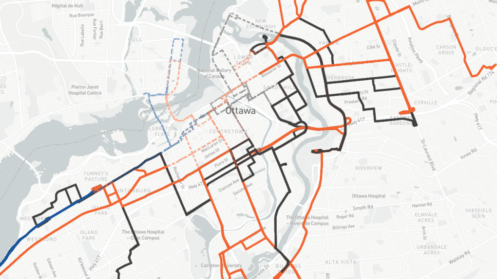
 A Carleton computer science student has made an interactive map showing the detours OC Transpo routes are being forced to take.
A new interactive map shows just how far buses in Ottawa are being forced to detour because of the ‘Freedom Convoy’ protest blocking downtown streets.
Derek Ellis, a computer science student at Carleton University, created a map that shows the significant detours OC Transpo buses are taking, many drastically different from their regular routes.
Ellis said he decided to make the map because OC Transpo has not released any maps or diagrams to show the detours.
“They just kind of had these worded descriptions,” he said. And even though the Centretown West resident has a good sense of downtown geography, he said they were hard to follow.
“I wanted to help anyone who has to use these routes right now just to get an idea of where they’re actually going,” he said.
The ongoing ‘Freedom Convoy’ occupation of downtown Ottawa has forced several bus routes out of the downtown core.
The map is a stark visualization of just how far they’re being detoured. The number 7 bus, for example, is forced to loop around at Hurdman Station to connect with LRT.
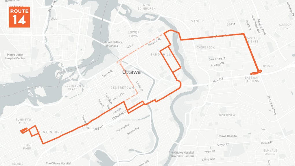
The number 14 bus, which usually travels down Elgin Street, instead goes south of the Queensway.
 The OC Transpo number 14 bus route is being completely diverted from downtown by the trucker protests.
Ellis said the map took him six hours to make. Most of that was gathering the data to show on the map, which he pulled from the city of Ottawa and OpenStreetMap.
He said he has received some positive feedback; a handful of people have expressed their appreciation for being able to see exactly where the buses are going.
“Hopefully people won’t be needing this for a long time, but at least while everything’s detoured, it’s nice to have,” he said.
“I’d hope that OC Transpo and the STO could provide these types of diagrams themselves,” he said. “Especially since this has been a prolonged detour, it would be helpful.”
You can view the map here.
CTVNews.ca Top Stories

FORECAST Weather warnings issued in 6 provinces and territories
Wintry weather conditions, including heavy snow and wind chill values around -55, prompted warnings in six provinces and territories early Thursday morning.
LIVE UPDATES The Latest: FBI investigating New Year's Day attack in New Orleans that killed at least 15 people
The FBI is investigating an early Wednesday attack in which a U.S. Army veteran drove a pickup truck into a crowd of New Year's revelers in New Orleans, killing 15 people. Here's the latest.
Who are Canada's top-earning CEOs and how much do they make?
Canada's 100 highest-paid CEOs earned $13.2 million on average in 2023 from salaries, bonuses and other compensation, according to the Canadian Centre for Policy Alternatives.
10 people are wounded in a shooting outside a New York City nightclub
Ten people were wounded in a shooting outside a New York City nightclub while they were waiting to get into a private event, police said.
Here's how immigration rules are changing in 2025
Canada's federal government is changing course on immigration with a wave of tighter caps on newcomers and new rules for permanent and non-permanent residents.
BREAKING Woman, father killed on New Year's Eve were victims of intimate partner violence: Halifax police
Halifax police are investigating three deaths that are connected – two of which they say were homicides resulting from intimate partner violence – in the city on New Year’s Eve.
'Dinosaur highway' tracks dating back 166 million years are discovered in England
A worker digging up clay in a southern England limestone quarry noticed unusual bumps that led to the discovery of a 'dinosaur highway' and nearly 200 tracks that date back 166 million years, researchers said Thursday.
Jocelyn Wildenstein, 'Catwoman' socialite known for her extreme cosmetic surgery, dies
Jocelyn Wildenstein, the Swiss-born socialite famous for the surgery-enhanced feline features that earned her nicknames in the American press like 'Catwoman,' has died.
opinion 7 tips to give yourself a financial restart this new year
The start of a new year is the perfect time to take control of your finances and set yourself up for success, says personal finance contributor Christopher Liew in a column for CTVNews.ca.


