Winter travel advisories end in Ottawa region; Sunday to be cold, partly sunny
Winter weather advisories and warnings across the region have ended and we’re in for a partly sunny and cooler than average Sunday in the capital.
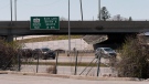
On Saturday, lake effect snow blew across parts of the region, especially along Highway 401, causing dangerous driving conditions, leading to numerous collisions. Another travel advisory for the Ottawa area was issued Saturday night, but ended by Sunday morning.
The official snowfall total for Ottawa on Saturday at the Ottawa Airport was 1.6 cm with another 0.4 cm falling by 7 a.m. Sunday.
According to Environment Canada, Brockville got the most snow this weekend, with 18.1 cm from 7 a.m. Saturday to 7 a.m. Sunday measured at the Brockville airport, north of town. Belleville saw 7.4 cm, while Kingston saw just 0.3 cm.
Environment Canada meteorologist David Rogers tells CTV News that measurements in town may be higher than the report from the automatic weather station. Currently, he says, there is a reading of 25 cm of snow on the ground, up from 3 cm on Friday.
CTV's Nate Vandermeer says he had 38 cm on his back deck Sunday morning.
Some advisories and warnings remain in effect in parts of Ontario, including the Peterborough area.
The current forecast for the city calls for just a few morning flurries and a partly sunny afternoon with a high of -4 C and a wind chill around -14.
The sky should clear by the evening, but expect clouds to move back in after midnight. The overnight low is -13 C.
The typical high for this time of year is closer to 4 C and the average low is closer to -4 C.
Monday could see the temperature rise above the freezing mark to a high of 2 C with about 2 cm worth of snow falling in the morning.
Tuesday’s outlook is sunny with a high of 0 C.


CTVNews.ca Top Stories

'Anything to win': Trudeau says as Poilievre defends meeting protesters
Prime Minister Justin Trudeau is accusing Conservative Leader Pierre Poilievre of welcoming 'the support of conspiracy theorists and extremists,' after the Conservative leader was photographed meeting with protesters, which his office has defended.
What is changing about Canada's capital gains tax and how does it impact me?
The federal government's proposed change to capital gains taxation is expected to increase taxes on investments and mainly affect wealthy Canadians and businesses. Here's what you need to know about the move.
'My stomach dropped': Winnipeg man speaks out after being criminally harassed following single online date
A Winnipeg man said a single date gone wrong led to years of criminal harassment, false arrests, stress and depression.
Bank of Canada officials split on when to start cutting interest rates
Members of the Bank of Canada's governing council were split on how long the central bank should wait before it starts cutting interest rates when they met earlier this month.
'One of the single most terrifying things ever': Ontario couple among passengers on sinking tour boat in Dominican Republic
A Toronto couple are speaking out about their 'extremely dangerous' experience on board a sinking tour boat in the Dominican Republic last week.
7 surveillance videos linked to extortions of South Asian home builders in Edmonton released
The Edmonton Police Service has released a number of surveillance videos related to a series of extortion cases in the city now dubbed 'Project Gaslight.'
Ukraine uses long-range missiles secretly provided by U.S. to hit Russian-held areas, officials say
Ukraine for the first time has begun using long-range ballistic missiles provided secretly by the United States, bombing a Russian military airfield in Crimea last week and Russian forces in another occupied area overnight, American officials said Wednesday.
Pilot reported fire onboard plane carrying fuel, attempted to return to Fairbanks just before crash
One of the two pilots aboard an airplane carrying fuel reported there was a fire on the airplane shortly before it crashed and burned outside Fairbanks, killing both people on board, a federal aviation official said Wednesday.
Manitoba government tables bill to end ban on homegrown recreational cannabis
Manitoba is planning to lift its ban on the home growing of recreational cannabis.
Shopping Trends
The Shopping Trends team is independent of the journalists at CTV News. We may earn a commission when you use our links to shop. Read about us.


Atlantic
-

Funeral to be held Wednesday for 16-year-old Halifax homicide victim
A funeral will be held Wednesday afternoon in Bedford, N.S., for a 16-year-old boy who died earlier this week following an incident near the Halifax Shopping Centre.
-
Cape Breton man earns $1.5M in Scratch’N Win
A Cape Breton man won $1.5 million after buying $200-worth of Atlantic Lottery Scratch’N Win tickets.
-
Officers arrest 5 people from Maine for fishing infractions in Digby County, N.S.
Fishery officers seized more than three kilograms of elvers and arrested five people from Maine for Fisheries Act infractions in Digby County, N.S., on Saturday night.
Toronto
-

Speed limits to increase on some sections of Ontario highways, province says
The Ontario government says it will be raising the speed limit along certain stretches of provincial highways soon, including Highway 401 and Highway 403.
-
New condo sales in the Toronto area hit low not seen since financial crisis
New condo sales in the Toronto region dropped to the lowest quarterly total since the financial crisis in 2009 amid high interest rates and affordability issues, a new report has found.
-
'One of the single most terrifying things ever': Ontario couple among passengers on sinking tour boat in Dominican Republic
A Toronto couple are speaking out about their 'extremely dangerous' experience on board a sinking tour boat in the Dominican Republic last week.
Montreal
-

'Highly complex' work delays REM completion to West Island, North Shore
The completion of Montreal's Reseau express metropolitain has been postponed yet again.
-
Quebec grants $40 million for cleanup of Montreal Olympic Stadium after fire
The Quebec government has awarded the organization that manages Montreal's Olympic Stadium up to $40 million to pay for repairs and decontamination after a March 21 fire.
-
BREAKING
BREAKING CFL suspends Shawn Lemon indefinitely for gambling
The CFL has suspended veteran defensive lineman Shawn Lemon indefinitely for betting on league games.
Northern Ontario
-

'My stomach dropped': Winnipeg man speaks out after being criminally harassed following single online date
A Winnipeg man said a single date gone wrong led to years of criminal harassment, false arrests, stress and depression.
-
An Ontario senior thought he called Geek Squad for help with his printer. Instead, he got scammed out of $25,000
An Ontario senior’s attempt to get technical help online led him into a spoofing scam where he lost $25,000. Now, he’s sharing his story to warn others.
-
Defence calls no witnesses in triple murder trial in Sudbury
The defence in a triple murder trial in Sudbury isn’t calling any witnesses and the jury will soon be deliberating the suspect’s fate.
Windsor
-

Essex concert series needs to pay its performers, say local musicians
If musicians are the sole focus of a commercial event, those performers should be paid for their efforts. That's according to a local musician who set up an online petition after the Town of Essex issued a call for artists to perform at their annual summer concert series for free.
-
Witnesses sought after Porsche and motorcycle collide
The Windsor Police Collision Reconstruction Unit is looking for witnesses after a collision involving a motorcycle and a Porsche.
-
Man arrested after police seize $10,000 in drugs
A 42-year-old man has been arrested after police seized $10,000 in illegal drugs.
London
-

How do U.S. decisions about TikTok impact Canada?
U.S. President Joe Biden has signed a bill that will force TikTok to be sold or be banned in his country, but what does it mean for Canada?
-
'I think 110 is fast enough': Speed limit to increase on some sections of 400 series highways
The speed you travel on sections of 400 series highways in our region is increasing. The province says it will raise the speed limit to 110 km/h on multiple sections, including some in the London region.
-
London, Ont. natives help Knights carry perfect record into Conference Final series with Saginaw
The London Knights went out in the offseason and acquired the goaltender they believed could lead them to a championship. So far, so good as Michael Simpson is a perfect 8-0 in the post season.
Kitchener
-

Undisclosed project filming in Cambridge today
Expect delays on Queen Street in Cambridge today as film crew shoots in the area.
-
Pedestrian seriously hurt after crash in Kitchener
A pedestrian had to be taken to an out-of-region hospital following a crash in Kitchener.
-
Grand River and St. Mary's hospitals could merge in 2025
Grand River Hospital and St. Mary’s General Hospital are looking to merge into a single new hospital organization by the spring of 2025.
Barrie
-

Suspected remains of missing Thornbury man found six years after disappearance
It was mid-October 2018 when Eric Spencer was last seen in Honey Harbour, a full-scale search by the OPP for the then 60-year-old from Thornbury scaled back when the search came up empty.
-
Video surveillance footage reveals bizarre break-in at local vet hospital
Barrie Police laid charges on a man after video surveillance captured him breaking into a store and smashing the front glass door.
-
Impaired driver fails breathalyzer test: OPP
Police laid impaired driving charges following a traffic stop in Brockton on Tuesday evening.
Winnipeg
-

Manitoba government tables bill to end ban on homegrown recreational cannabis
Manitoba is planning to lift its ban on the home growing of recreational cannabis.
-
'I just wanted to stand out': Winnipeg Jets fan goes viral for wearing salmon shirt at Whiteout
A Winnipeg Jets fan found a unique way to stand out amid the Winnipeg Whiteout; he wore a salmon-coloured shirt.
-
Child dies following collision with trailer: Brandon police
A four-year-old child has died following a collision with a trailer in Brandon, Man.
Calgary
-

'Disingenuous and misleading': Calgary mayor, province at odds over plan to lower utility bills
Calgary's mayor is sparring with the Government of Alberta over the rollout of new legislation meant to lower utility bills in Calgary.
-
Bell no longer a Calgary Stampede sponsor after nearly 20 years
Bell Canada, the parent company of CTV News, is no longer a sponsor of the Calgary Stampede.
-
Olivia and Noah remain the top choices in Alberta for baby names
Alberta's top baby names in 2023 were released on Wednesday with familiar names topping the list.
Edmonton
-

7 surveillance videos linked to extortions of South Asian home builders in Edmonton released
The Edmonton Police Service has released a number of surveillance videos related to a series of extortion cases in the city now dubbed 'Project Gaslight.'
-
All Alberta wildfires to date in 2024 believed to be human-caused: province
There are 63 wildfires burning in Alberta's forest protection area as of Wednesday morning and seven mutual aid fires, including one in the Municipal District of Peace.
-
8.9% property tax approved by Edmonton council
Edmonton city council unanimously agreed on an 8.9-per cent property tax increase Tuesday evening.
Regina
-

Sask. police caught 454 impaired drivers in March: SGI
Saskatchewan police caught 454 impaired drivers around the province in March. Of those, 142 are facing Criminal Code charges and the other 312 faced licence suspensions, according to a news release from Saskatchewan Government Insurance (SGI).
-
Saskatchewan to update aging air tanker fleet beginning in 2025
The Government of Saskatchewan has purchased four re-purposed Dash-8 airliners to replace elements of its air tanker fleet in the next three years.
-
Gang unit operation in west Regina leads to firearms and drugs seized, 2 arrests
Two people are facing charges following an investigation into drug trafficking and firearms in Regina.
Saskatoon
-
Sask. woman fights to find out who had her apprehended for a psych. assessment
A Saskatchewan woman who was taken for an involuntary mental health assessment is entitled to find out who had her committed, a provincial court judge has ruled.
-
Punched, kicked, spat on: Saskatoon Transit workers call for help after violent assaults
The union representing the city’s bus drivers says violence against transit workers is out of control.
-
Saskatoon man turned himself in after violent stabbing
A 25-year-old Saskatoon man faces charges in relation to a stabbing that left a 34-year-old man in hospital on Tuesday.
Vancouver
-

Brothers Keepers gang member in B.C. sentenced to 11 years in prison
A member of the Brothers Keepers gang in British Columbia, which police describe as an 'extremely violent organized crime group,' has been sentenced to 11 years in prison on drug-trafficking charges.
-
Inspector orders Vancouver mushroom dispensary to close – again
The founder of an embattled psilocybin mushroom dispensary in Vancouver's Mount Pleasant neighbourhood has vowed to keep the business running, despite an order from the city's chief licensing inspector.
-
Fatal stabbing near White Rock promenade under investigation: RCMP
A homicide is under investigation in White Rock, B.C., marking the second stabbing near the waterfront promenade in a 48-hour period.
Vancouver Island
-
Brothers Keepers gang member in B.C. sentenced to 11 years in prison
A member of the Brothers Keepers gang in British Columbia, which police describe as an 'extremely violent organized crime group,' has been sentenced to 11 years in prison on drug-trafficking charges.
-
Mounties will not be charged in shooting death of B.C. Indigenous man
Three Mounties in British Columbia will not face charges in the killing of a 38-year-old Indigenous man on Vancouver Island in 2021.
-
Vancouver Island man realizes childhood dream alongside Hollywood icon
To appreciate the two posters hanging in Stephen Campanelli’s laundry room, which he’s had for more than 40 years, you need to know he’s been a Clint Eastwood fan for even longer.
Kelowna
-

Search crews called in after missing Kelowna senior's truck found
Search and rescue crews have been called in after a vehicle belonging to a missing senior was located near a rural intersection outside of Kelowna Tuesday.
-
Homicide investigation underway after body found near Kelowna, B.C.
Major crime detectives in British Columbia are investigating a suspected homicide after a body was found in a remote area southeast Kelowna over the weekend.
-
Stolen snake named Milkshake returned to Kelowna pet store
A banana ball python that was stolen from a Kelowna pet store on Saturday has been returned unharmed, Mounties said.


