Rain on the way would delay water level decrease on Ottawa River
A rainy few days could extend the flooding along the Ottawa River, just as water levels were beginning to stabilize.
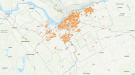
The Ottawa River Regulation Planning Board says water levels are slowly approaching major flood thresholds from Chats Lake, in the Ottawa Valley, to the Montreal area.
The board warns heavy rain in the forecast may result in "additional level increases" in some locations along the Ottawa River starting on Monday, depending on the amount and location of the rainfall.
Manon Lalonde, executive engineer with the Ottawa River Regulation Secretariat, told Newstalk 580 CFRA's "CFRA Live with Andrew Pinsent" Saturday morning that were it not for the rain in the forecast, people living along the banks of the Ottawa River would start to see water levels go down.
"Most of the melt water from the central part of the basin has made its way to the river and is leaving the system," she said. "If it weren't for the rain that we're seeing over parts of the basin… levels would start to decline everywhere."
Lalonde notes that Environment Canada has issued rainfall warnings for parts of western Quebec, warning of up to 30 mm by Sunday.
"The main effect of that rain will be to delay the decline of the water level. It is always possible that there will be some increases in some locations. It's really tough to tell at this part of time," Lalonde added.
"These additional increases that may come starting Monday, we're talking additional inches, we're not talking feet. This is what we're seeing over the next few days."
WEATHER FORECAST
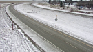
Ottawa saw some brief showers Saturday morning. Environment Canada was forecasting about 5 mm of rain early Saturday followed by a partly sunny day with a high of 23 C. Wind gusts could reach 50 km/h, Saturday. The UV index is 9, or very high.
However, more rain is expected Saturday evening and overnight. The forecast calls for 10 to 15 mm of rain and the risk of a thunderstorm with a low of 7 C.
Sunday's forecast includes another 5 to 10 mm of rain and a high of 14 C.
Overnight lows in the low single digits are forecast for the start of the next week. Monday could see a few flurries in the morning changing to rain showers as the temperature rises. The high is 13 C.
There is a small chance of showers in the long-term outlook through next week, though most days should see sunny breaks. Highs are in the low teens.
--With files from CTV News Ottawa's Josh Pringle and Peter Szperling.


CTVNews.ca Top Stories

'It could be catastrophic': Woman says natural supplement contained hidden painkiller drug
A Manitoba woman thought she found a miracle natural supplement, but said a hidden ingredient wreaked havoc on her health.
After hearing thousands of last words, this hospital chaplain has advice for the living
Hospital chaplain J.S. Park opens up about death, grief and hearing thousands of last words, and shares his advice for the living.
WHO likely to issue wider alert on contaminated cough syrup
The World Health Organization is likely to issue a wider warning about contaminated Johnson and Johnson-made children's cough syrup found in Nigeria last week, it said in an email.
WATCH
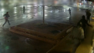
WATCH Video shows dramatic police takedown of carjacking suspects chased through parking lot north of Toronto
Police have released video footage of a dramatic takedown of a group of teens wanted in connection with an attempted carjacking in Markham earlier this month.
Canada, G7 urge 'all parties' to de-escalate in growing Mideast conflict
Canada called for 'all parties' to de-escalate rising tensions in the Mideast following an apparent Israeli drone attack against Iran overnight.
'It was all my savings': Ontario woman loses $15K to fake Walmart job scam
A woman who recently moved to Canada from India was searching for a job when she got caught in an online job scam and lost $15,000.
Families to receive Canada Child Benefit payment on Friday
More money will land in the pockets of some Canadian families on Friday for the latest Canada Child Benefit installment.
After COVID, WHO defines disease spread 'through air'
The World Health Organization and around 500 experts have agreed for the first time on what it means for a disease to spread through the air, in a bid to avoid the confusion early in the COVID-19 pandemic that some scientists have said cost lives.
American millionaire Jonathan Lehrer denied bail after being charged with killing Canadian couple
American millionaire Jonathan Lehrer, one of two men charged in the killings of a Canadian couple in Dominica, has been denied bail.
Shopping Trends
The Shopping Trends team is independent of the journalists at CTV News. We may earn a commission when you use our links to shop. Read about us.


Atlantic
-
'Dangerous man' with firearm in Bible Hill in custody: N.S. RCMP
The RCMP says a 'dangerous man' with a firearm in Bible Hill, N.S., is in custody Friday morning.
-
Price of gas jumps nearly 10 cents in Nova Scotia
As predicted, gas prices increased overnight in the Maritimes, though the price of diesel decreased by a few cents.
-
P.E.I. woman dies after crash in Grand River: RCMP
Police on Prince Edward Island say a woman has died following a Thursday afternoon car crash.
Toronto
-
 WATCH
WATCHWATCH Video shows dramatic police takedown of carjacking suspects chased through parking lot north of Toronto
Police have released video footage of a dramatic takedown of a group of teens wanted in connection with an attempted carjacking in Markham earlier this month.
-
'It was all my savings': Ontario woman loses $15K to fake Walmart job scam
A woman who recently moved to Canada from India was searching for a job when she got caught in an online job scam and lost $15,000.
-
Families to receive Canada Child Benefit payment on Friday
More money will land in the pockets of some Canadian families on Friday for the latest Canada Child Benefit installment.
Montreal
-

American millionaire Jonathan Lehrer denied bail after being charged with killing Canadian couple
American millionaire Jonathan Lehrer, one of two men charged in the killings of a Canadian couple in Dominica, has been denied bail.
-
Here are the Montreal road closures planned for the weekend
Those driving in and around Montreal on the weekend should be aware that construction work will result in some major route closures.
-
Quebec judge suspends parts of Bill 96 that apply to English school boards
The English Montreal School Board (EMSB) is celebrating what it calls a 'significant win' in court after a judge stayed parts of Quebec's language laws that apply to English school boards across the province.
Northern Ontario
-
 BREAKING
BREAKING Sudbury police investigating threat found in high school bathroom stall
Sudbury police will have an increased presence at a local high school after two threatening messages were found in a bathroom stall.
-
Fatal crash at northern Ont. business on Highway 17
One person has died as the result of a single-vehicle crash at a northern Ontario business on Highway 17 on Thursday afternoon, police say.
-
Families to receive Canada Child Benefit payment on Friday
More money will land in the pockets of some Canadian families on Friday for the latest Canada Child Benefit installment.
Windsor
-

Police in Windsor looking for Ramtin Bayat
Windsor police are asking the public to keep an eye out for a man last seen in the downtown area.
-
Store employee threatened with knife during robbery
Police said a person went to a market in the 2100 block of Huron Church Road near McKay Avenue and left the store without paying for about $200 worth of items.
-
Missing 82-year-old man has been found
Windsor police have located an 82-year-old man.
London
-

Human trafficking-related charges laid by London police
London police have charged a man from Manitoba with human trafficking-related charges. Police in the 600 block of Wellington Rd. near Wilkins Street when they saw a vehicle with stolen plates in a parking lot.
-
Crash causes power outage in St. Thomas
According to police, there was “significant damage” to the hydro pole, causing a power outage to the surrounding areas.
-
Man arrested after police locate stolen vehicle
A Lucan man is facing a number of charges after police said they recovered a stolen truck.
Kitchener
-

Landlords reporting increase in tenants refusing to pay rent or leave
A property management company in Fergus is still cleaning up after they say a tenant trashed one of their units and refused to pay rent -- and they say it's not the only similar case they've dealt with recently.
-
Strange beasts stalking Silver Lake in Waterloo
Don’t be alarmed if you see some strange new creatures in Waterloo Park.
-
Ontario Review Board hearing considers Udo Haan’s future
An Ontario Review Board hearing was held at the Southwest Centre for Forensic Mental Health Care in St. Thomas on Thursday to consider the future of Udo Haan.
Barrie
-

Serious rollover on Highway 400 sends mother to hospital
Person airlifted to Toronto after a rollover on Highway 400 Friday morning.
-
Clock ticking on CAA's Worst Roads campaign
CAA's Worst Roads campaign ensures municipalities know which roads its residents feel need rapid improvement.
-
Driver suffers life-threatening injuries in Hwy 12 collision
One person suffered life-threatening injuries after a collision with a commercial vehicle on Highway 12 at Forest Avenue in Orillia early Thursday afternoon.
Winnipeg
-
'It could be catastrophic': Woman says natural supplement contained hidden painkiller drug
A Manitoba woman thought she found a miracle natural supplement, but said a hidden ingredient wreaked havoc on her health.
-
Winnipeg Jets release Round 1 playoff schedule
The Winnipeg Jets have released its first round playoff schedule.
-
WINSAR members ready to answer the call for missing persons
In southern Manitoba, members of Winnipeg Search and Rescue (WINSAR) remain vigilant as they assist in finding a missing Manitoban.
Calgary
-

Calgary mayor to comment on controversial rezoning plan
Mayor Jyoti Gondek is expected to share her thoughts on Calgary's rezoning plan – one of the most contentious issues to face the city in recent years.
-
City of Calgary to respond to Alberta water-sharing announcement
The City of Calgary is going to provide an update on its drought preparedness plan and respond to the province’s water-sharing agreements on Friday.
-
Students helping food insecure students through the U of C's Science Community Garden
Science students at the University of Calgary use their roof top greenhouse to conduct all kinds of projects and had a little extra space that wasn't being used. so some of them came up with the idea of growing food for the campus food bank.
Edmonton
-

MacKinnon has 2 assists, breaks franchise's single-season points mark as Avs beat Oilers 5-1
Valeri Nichushkin scored twice, Nathan MacKinnon added two assists to break the franchise’s single-season points mark and the Colorado Avalanche cruised into the playoffs behind a 5-1 win over the Edmonton Oilers on Thursday night.
-
WEATHER
WEATHER Josh Classen's forecast: Cool spell ends today as warmer air returns through the weekend
We'll get our fourth consecutive cooler-than-average day today and that's where the streak will end.
-
New study explores visitor experiences in Alberta dark sky preserves
The health and environmental benefits of protecting a region from light pollution are already well established, and one only has to look at the stream of visitors to the Jasper Dark Sky Festival or the Alberta's newest dark sky preserve in Lakeland Provincial Park to get a sense of how "astrotourism" can boost rural economies.
Regina
-
Travel not recommended on several Sask. highways Friday morning
As a 'Colorado hybrid' system continues to bring snow and gusty winds to parts of Saskatchewan, highway conditions have continued to deteriorate over the past 48 hours.
-
New crash course focused on getting Sask. youth excited about journalism
Fifteen youth from a variety of backgrounds are taking on the monumental task of creating and performing a live radio broadcast with on seven days to prepare. The goal of the project is to get more youth excited about journalism.
-
'Poor choice of words': Education Minister apologizes for remarks made to Sask. mother
On Thursday, Education Minister Jeremy Cockrill apologized for remarks he made to a mother who had advocated for better classroom supports earlier this week.
Saskatoon
-
Travel not recommended on several Sask. highways Friday morning
As a 'Colorado hybrid' system continues to bring snow and gusty winds to parts of Saskatchewan, highway conditions have continued to deteriorate over the past 48 hours.
-
'Poor choice of words': Education Minister apologizes for remarks made to Sask. mother
On Thursday, Education Minister Jeremy Cockrill apologized for remarks he made to a mother who had advocated for better classroom supports earlier this week.
-
Saskatoon police committing three officers to curb crime in Pleasant Hill
The Saskatoon Police Service (SPS) is dedicating three officers to a specialized unit to help curb crime in the Pleasant Hill neighbourhood.
Vancouver
-

Off-duty Mountie cleared of wrongdoing after cyclist seriously injured in Langford, B.C.
British Columbia's police watchdog has cleared an off-duty Mountie of wrongdoing after a cyclist suffered serious injuries in a collision with an unmarked police vehicle last month.
-
Facebook Marketplace seller must refund buyer over false advertising, B.C. tribunal decides
A Facebook Marketplace seller is being ordered by B.C.'s small claims tribunal to repay hundreds of dollars after selling a product under false advertising.
-
Teen charged with 4 counts of robbery after allegedly snatching iPhones at SkyTrain station
Metro Vancouver Transit Police say a young offender has been charged with four counts of robbery in relation to incidents that occurred at a Burnaby transit hub over the course of a year.
Vancouver Island
-
Off-duty Mountie cleared of wrongdoing after cyclist seriously injured in Langford, B.C.
British Columbia's police watchdog has cleared an off-duty Mountie of wrongdoing after a cyclist suffered serious injuries in a collision with an unmarked police vehicle last month.
-
Bigger boats, more nets, people arrive in Zeballos, B.C., for new orca rescue attempt
A large seine fishing vessel capable of casting a net strong enough to hold a nearly 700-kilogram killer whale calf has arrived in Zeballos, B.C., to participate in the latest attempt to rescue the young orca stranded in a remote tidal lagoon.
-
Facebook Marketplace seller must refund buyer over false advertising, B.C. tribunal decides
A Facebook Marketplace seller is being ordered by B.C.'s small claims tribunal to repay hundreds of dollars after selling a product under false advertising.
Kelowna
-

Stolen snake named Milkshake returned to Kelowna pet store
A banana ball python that was stolen from a Kelowna pet store on Saturday has been returned unharmed, Mounties said.
-
Nurses rally at B.C. Interior hospital over security, staffing concerns
Nurses held a rally Wednesday at a hospital in the B.C. Interior that closed its emergency department more than a dozen times last year due to insufficient staff.
-
B.C. to add 240 complex-care housing units throughout province
British Columbia is planning to add 240 new units to its complex-care housing program, providing homes for people with mental-health and addictions challenges that overlap with other serious conditions.


