
BREAKING
After a milder-than-usual January with several significant snowfalls, expect things to cool down in the capital this week.
The colder weather comes after another fresh snowfall on Sunday slowed driving across the city.
Environment Canada reported 18 cm of snow at the Ottawa airport on Sunday. Conditions at there have been windy, which has interfered with the snowfall measurements, so the 18 cm of snow is an estimate.
A winter weather travel advisory for Ottawa and eastern Ontario ended just after 7 p.m. Sunday evening as the system moved out of the region.
An overnight parking ban was in effect starting 7 p.m. Sunday night and was lifted at 7 a.m. Monday.
On Monday, Environment Canada is calling for a high of -7 C, with a wind chill of -17 to start the day.
Expect a bit more snow Monday night (about 2 cm) that will end just after midnight. The low overnight will be -16 C.
Tuesday will be sunny with a high of -8 C. The wind chill in the morning will make it feel like -20.
Wednesday will see a mix of sun and cloud with a high of -6 C. Thursday will be cloudy with a high of -2 C and a 40 per cent chance of flurries.
Then, the truly bone-chilling temperatures start in time for the weekend. Friday will be sunny with a high of -20 C and a low of -31 C. And Saturday has a forecast high and low of -17 C. That is not a typo: the forecasted high and the forecasted low are the same temperature.

Drivers in Eastern Canada face a big increase in gas prices because of various factors, especially the higher cost of the summer blend, industry analysts say.
The journey to home ownership can be exciting, but personal finance columnist Christopher Liew warns about the trappings of becoming 'house poor' -- where an overwhelming portion of your income is devoured by housing costs. Liew offers some practical strategies to maintain better financial health while owning a home.
As the United States sets its first national limits on toxic forever chemicals in drinking water, researchers say Canada is lagging when it comes to regulations.
A Winnipeg woman was sentenced to house arrest after a single date with a man she met online culminated in her harassing him for years, and spurred false allegations which resulted in the innocent man being arrested three times.
It took years for Vinnie Deluca to collect more than 400 cards worth of free McDonald's McCafe coffee, a collection that now has "zero value" after the company discontinued the program.
U.S. President Joe Biden will accept endorsements from at least 15 members of the Kennedy political family during a campaign stop in Philadelphia on Thursday as he aims to undermine Donald Trump and marginalize the candidacy of Robert F. Kennedy Jr.
Almost 7,000 bars of pure gold were stolen from Pearson International Airport exactly one year ago during an elaborate heist, but so far only a tiny fraction of that stolen loot has been found.
New archeological investigations in Guatemala reveal that the ancient Maya people had a ritual of burning royal human remains as a public display of political regime change.
Mullett Arena buzzed like few times in the two years since the Arizona Coyotes moved in, the fans amped for one last desert hurrah.
The Shopping Trends team is independent of the journalists at CTV News. We may earn a commission when you use our links to shop. Read about us.

The RCMP says it is investigating a sudden death in Nova Scotia’s Colchester County.
Drivers in Eastern Canada face a big increase in gas prices because of various factors, especially the higher cost of the summer blend, industry analysts say.
A Celebrity Apex cruise to the Caribbean this month turned into a rocking Newfoundland kitchen party when hundreds of people from Canada's easternmost province happened to be booked on the same ship.

It took years for Vinnie Deluca to collect more than 400 cards worth of free McDonald's McCafe coffee, a collection that now has "zero value" after the company discontinued the program.
A man has been taken to hospital with life-threatening injuries following an industrial accident in Mississauga.
As the United States sets its first national limits on toxic forever chemicals in drinking water, researchers say Canada is lagging when it comes to regulations.

Motorists are facing higher prices in many parts of Quebec as gas stations switch from winter to summer gasoline.
Quebec provincial police say a body was found following a fire in Saint-Georges, in the Beauce region.
Quebec Premier François Legault didn't wait long to replace his government whip.

A northern Ont. city councillor says she fears many women will go without the proper health care after town loses access to mobile cancer screening.
The body of a missing man has been found after his vehicle was pulled into a northern creek on Saturday morning, Ontario Provincial Police say.
Drivers in Eastern Canada face a big increase in gas prices because of various factors, especially the higher cost of the summer blend, industry analysts say.
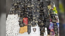
Windsor police have seized nearly $42,000 in illegal drugs after raiding a psilocybin dispensary. Around 4 p.m. on Tuesday, police used a search warrant at the business in the 300 block of Ouellette Ave. near University Avenue.
Morgan Hurt shares a birthday with her grandfather, Bruce Rand – but it’s the fact both have received life-saving organ donations that has really solidified their special bond.
Many made a dash to the pumps because experts say the price of gas is set to rise Thursday.

According to the London Police Service (LPS), a 35-year-old Constable who lives in Woodstock was arrested and charged with impaired driving.
The rapid pace of infrastructure needed to build the largest factory in Canada continues.
The first joint meeting by the elected councils of the City of London and Oneida Nation of the Thames saw the long-time neighbouring communities take a collaborative step forward.

People living in the community of Ayr say they are dealing with a safety concern due to transport trucks travelling through their downtown.
Pizza and coffee wasn’t what Jeet Shergill was expecting to order on his lunch break, but he saw the posters of the new menu item at Tim Hortons and decided to give it a shot.
A woman from Guelph, who allegedly tried to obtain credit fraudulently at Conestoga Mall, is now facing 42 charges.

Provincial police are investigating after a man's body washed up on the shores of Lake Couchiching in Severn Township.
Tim Hortons Roll Up The Rim contest may be in hot water yet again after several customers received emails falsely congratulating them on winning the Tracker boat worth nearly $60,000.
A multi-vehicle collision involving a semi-truck snarled traffic in Barrie on Wednesday afternoon.

A Winnipeg man is raising a red flag after his landlord said no to health-care equipment that could change his life – a problem he believes is a human rights issue.
A Winnipeg woman was sentenced to house arrest after a single date with a man she met online culminated in her harassing him for years, and spurred false allegations which resulted in the innocent man being arrested three times.
A motion filed by the man accused of killing four Indigenous women in Winnipeg to have one of those murder charges quashed has been dismissed by the judge – weeks before the start of his trial.

Calgary police have arrested a man and a charge is pending in connection with the death of a toddler in 2022.
Two people are in hospital and police are investigating a fight between a man and a woman in Forest Lawn early Thursday morning.
Alberta's toxic drug death toll has been blamed on a worsening "addiction crisis" and “soaring addiction rates for opioids and other substances,” but data shows no increase in rates of substance use disorders over last decade.

The Coyotes closed out their 28-year Arizona tenure as winners, getting a goal and an assist from Dylan Guenther in a 5-2 victory over the Edmonton Oilers on Wednesday night.
Alberta's toxic drug death toll has been blamed on a worsening "addiction crisis" and “soaring addiction rates for opioids and other substances,” but data shows no increase in rates of substance use disorders over last decade.
Inflationary pressures, limited funding and vacancy downtown means CKUA needs 3 million dollars by the end of September to stay in business.

After two days of negotiations, the province has presented the Saskatchewan Teachers’ Federation (STF) a final offer, which will go to members for a vote.
A Regina man who says he was given two hours to vacate the seniors' home he lived in after being evicted should not have been forced to move in the first place.
The Saskatchewan Urban Municipalities Association (SUMA) conference wrapped up on Wednesday with educational sessions in the morning, followed by a bear pit session for delegates to speak directly with the provincial government.

The woman accused of hitting and killing a child while driving under the influence of THC was called to the stand on Wednesday.
After two days of negotiations, the province has presented the Saskatchewan Teachers’ Federation (STF) a final offer, which will go to members for a vote.
A former massage therapist who pleaded guilty to a string of sexual assaults has had his day parole revoked.

A banana ball python that was stolen from a Kelowna pet store on Saturday has been returned unharmed, Mounties said.
Around 100 members of the Union of Canadian Correctional Officers plan to hold a protest in Abbotsford, B.C., today.
The lawyer representing child-killer Allan Schoenborn walked out of his client's annual review hearing Wednesday – abruptly ending proceedings marked by tense exchanges and several outbursts.

The British Columbia government is encouraging anglers to pack their tackle boxes and head out to a remote lake on Vancouver Island as the province attempts to eradicate an invasive population of sport fish.
Evan Jamieson’s nine-year-old son Oliver has thrived at Mill Bay Nature School in Mill Bay, B.C., despite all of his challenges.
B.C.'s police watchdog has finished its investigation into an incident on Vancouver Island, concluding the actions of officers weren't connected to a man's death.
A banana ball python that was stolen from a Kelowna pet store on Saturday has been returned unharmed, Mounties said.
Nurses held a rally Wednesday at a hospital in the B.C. Interior that closed its emergency department more than a dozen times last year due to insufficient staff.
British Columbia is planning to add 240 new units to its complex-care housing program, providing homes for people with mental-health and addictions challenges that overlap with other serious conditions.